September 26, 2010

Big Cottonwood Superloop


Elevation profile of the "Superloop." According to TOPO!, we gained well over 8000 feet of vertical!

Date:
September 25, 2010
Distance: ~20.5 miles
Vertical: ~8600 feet
Time: 11.5 hours
Peaks: Desolation Peak (9,990 ft), Silver Benchmark (10,006 ft), PT 10,009, Scott Hill (10,116 ft), Tri-County Peak (10,026 ft), PT 10,420, Clayton Peak (10,721 ft), Preston Peak (10,315 ft), Pioneer Peak (10,460 ft), Sunset Peak (10,648 ft), Mt Tuscarora (10,660 ft), Mt Wolverine (10,795 ft), Davenport Hill (10,140 ft)
Route: Start at Spruces Campground, Mill D trail to Park City Ridge just below 9990', follow ridge all the way to Davenport Hill, return to car via Days Fork.

We've had this hike on our calendar for about 2 months. Bradley Yates of the Wasatch Mountain Club organized this group outing and came up with the idea for this fantastic loop. We met 7 other club members at 6am on Saturday morning, and we're heading up the Mill D trail before 6:30am. The loop was essentially just a really long hike (nothing technical) with LOTS of ups and down. We picked up the ridge near Desolation Peak, and followed it all the way South, past Brighton, past Alta, and then headed back West before dropping down the Days Fork trail. Overall we topped out on 13 peaks (I think... it got hard to keep track after a while!), and according to my TOPO! software, climbed over 8500 feet of vertical. It was a pretty long day and a nice workout. You always feel good after a big vertical day. The fall foliage is about at peak in the Wasatch, so the timing for this loop was perfect.


Overview of the route relative to SLC


The entire route


The full moon still hanging out in the morning


Aspens starting to turn yellow


On the PC ridge


Looking towards Solitude


The group on the ridge


Aspens


Hiking along...


Andrea on one of the peaks... I can't even remember which one at this point


Sunset and Tuscarora


Sunset Peak and Lake Catherine


Twin Lakes Reservoir

September 20, 2010

Bryce Canyon National Park


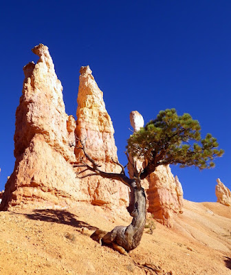
Bryce Canyon Amphitheater

Andrea and I spent this past weekend at Bryce Canyon National Park in Southern Utah. Salt Lake was getting hit with a late-summer heat blast, so we wanted to go somewhere cool. Since we're both feeling the pain of plantar fasciitis, so an easy car-camping (yes, its allowed! :-) weekend was just what the doctor ordered.

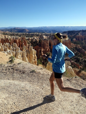
If you've ever been to Bryce, you already know that the landscape is absolutely out of this world. We had perfect weather; the nights were cold, but while the sun was out it was warm and comfortable. On Saturday morning we got to Bryce Point around 5:30am and waited for the sun to rise, which was pretty spectacular. The rest of the morning was spent exploring the trails in Bryce Amphitheater. We went for a run on the rim trail in the afternoon, where the vistas were so stunning that any heel pain didn't register in the brain! I wish I had brought my camera on that run, because the amphitheater looked even more amazing than it did in the morning! On Sunday morning I did bring my camera on our run (starting at Fairyland Point), and was able to get some nice action shots with the unique scenery.

Note for runners: The Rim Trail is awesome for an easy run with some rollers. You can make an our-and-back as long as you want, and the views on the way back are always different than what you saw on the way out, so it never gets old. The Fairyland Trail to Rim Trail loop is the coolest place either of us had ever run (we came to that conclusion just a few miles into the loop and it continued to get better and better). If you start from Fairyland Canyon, you'll have a solid 600+ foot climb to re-gain the canyon rim. The trail is smooth double-track the whole way. Bottom line: If you're in the vicinity of Bryce, and you're a runner, take advantage of these trails. Of all the parks I've visited, Bryce in the best for trail running. The trails are really easy for hiking, but running makes it a nice challenge and allows you to see most of the park in a short period of time.

As always, I took plenty of photos...


The amphitheater...


...again, just before the sun broke over the horizon...


...and just after it broke over the horizon


Crowd at Bryce Point


Wall Street


Thor's Hammer


The "Utah Wobbler" - only my parents appreciate the significance of this photo! :-)


Running on the Fairyland Trail


Andrea running in this panoramic


We stopped to see some ponies on the way back to SLC. Turns out they are actually pretty lame animals... unicorns are way cooler.


We made our traditional stop at the Dairy Queen in Scipio, UT

September 12, 2010

The Bullion Divide


Some of the peaks on Little Cottonwood Canyon's Alpine (South) ridge [photo taken in late June]. The Bullion Divide traverses from Sugarloaf Peak to Red Baldy. I intended on going extending the traverse all the way to Pfeifferhorn (green arrows) but ended up bailing early (purple arrows).

Date: September 12, 2010
Distance: ~15 miles total
Vertical: ~6000 feet
Time: 8 hours
Peaks: Sugarloaf Peak (11,051 ft), Mt Baldy (11,068 ft), Hidden Peak (10,992 ft), East Twin Peak (11,433), West Twin Peak (11,489), Red Top (11,378), Red Baldy (11,171)
Route: White Pine trailhead to Albion Basin on the road. Then climbed Sugarloaf Peak, traversed the ridge to Red Baldy, and descended down the NW slopes and White Pine trail.

The Bullion Divide is once of the classic Wasatch ridge traverses, usually starting at Albion Basin (Alta ski area) and ending somewhere past Snowbird. Summitpost describes the route as terminating at White Baldy, while the Wasatch Mountain Club describes it as ending at Red Baldy. With Andrea out of town this weekend, I wanted to do a longer traverse than either of those descriptions, and intended on taking the divide route all the way to Pfeifferhorn. To add to the challenge, I'd add a 6 mile, 2000 foot hike before starting the route (this route usually requires a car shuttle, but since I was hiking solo, I had to walk from the end of the route to the beginning). I ended up "just" doing that standard route, because I'm struggling with a case of plantar fasciitis, so I bailed after climbing Red Baldy. It was still a great hike with beautiful views and some fun scrambling sections. I hit the top of 7 peaks (5 ranked with 300' of prominence). This is a hike that I'll definitely want to repeat in the spring (with snow!). My splits are below and the pictures (which came out great thanks to some wispy clouds) are below as well...

Start from White Pine TH - 7:30am
Cecret Lake TH - 8:55am
Sugarloaf Peak - 10:02am
Mt Baldy - 10:37am
Hidden Peak - 10:57am
East Twin Peak - 11:46am
West Twin Peak - 11:57am
Red Top - 12:12pm
Red Top / Red Baldy saddle - 12:44pm (this segment took forever b/c the rock was loose and it was killing my foot)
Red Baldy - 1:15pm
White Pine TH - 3:30pm (the descent off Red Baldy was not fun without snow)


My intended route in green, which I followed until Red Baldy and then descended via the purple route


Starting off at 7:30am. I only took this b/c I got my new Utah license plates this week!


Passing by Snowbird


Passing by Alta


"Our Lady of the Snows Church" in the town of Alta. They pray for snow here... and apparently pray HARD b/c Alta gets about 50 feet per winter!


My first target, Sugarloaf Peak, to the left


Cecret Lake (yeah that's how its spelled)


Looking towards the next 4 peaks I'll reach


Cecret Lake from the top of Sugarloaf


At the border b/w Alta and Snowbird. Mt Baldy is up the ridge to the right.


Looking down Little Cottonwood from Mt Baldy


Hidden Peak and Twin Peaks from Mt Baldy


The Snowbird tram


The next goal was to follow the ridge starting on the left that snakes its way up towards the east twin...


...here's what the same area looked like when we were skiing here in April!


The lower section of the ridge had some pseudo-knife edge sections... if you look closely, you can see....


... an anchor BOLTED into the rock?!? I can't imagine using ropes here would be necessary, but I did put my helmet on when I reached this section.


Some of the steeper sections on the ridge. The rock was solid and it was fun climbing.


On the East Twin, looking towards the West Twin, Red Top, and Red Baldy


Looking back down the ridge I climbed


Looking East... all the peaks I had climbed so far are visible


After the Twin Peaks, I made the quick jaunt up to Red Top. That part was fine, but going down was miserable... I had to descend this ridge, which was all loose rotten rock. My foot was killing me at this point, and I thought about bailing at the saddle, but the climbing on Red Baldy looked fun, so I decided one more peak was in order...


This buttress and ridge up to Red Baldy looked fun!


Looking down from the first buttress. I stayed right on the ridge crest... it was steep and exposed, but surprisingly solid. You could probably bypass some of the difficulties by dropping to the east side of the ridge, but that would have been boring!


Excited for this last pitch!


On the summit - White Baldy (double summit to the left) and Pfeifferhorn (pyramid shaped peak in the center) were on the original agenda, but I had to call it a day at this point :-(


Obligatory shot of Timp. The snowfield is almost completely melted out! Its been a hot summer!


Scoping for the winter... this looks like a fun snow climb route.


NW slopes of Red Baldy. Much easier to travel across when its covered in 10 feet of snow!


More boulderfields


Red Top looks to have some awesome ski terrain


North Ridge of LCC. I love how the rock changes color a few hundred feet from the top.


Back at the trailhead... WOW I need these kind of shades for my jeep!